Fail:Great Lakes bathymetry map.png
Originaline fail (1024 × 731 piksel'ad, failan suruz': 1,34 mb, MIME-tip: image/png)
Lühüd kirjutuz
| Kirjutuz |
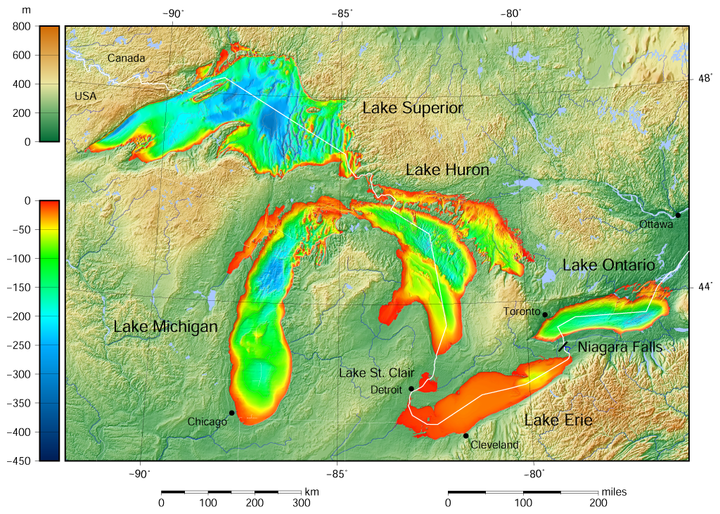
English: Great Lakes bathymetry and surrounding area shaded relief map. Lakes are contoured with interval 100 m. Lake Superior is incomplete. |
| Päiv | |
| Augotižtekst |
Own work using: the following Public Domain datasets (grids):
The color palette of the depth scale was made to be more or less similar to the color palettes used on the NGDC Great Lakes maps. |
| Tegii | Darekk2 using the Great Lakes Bathymetry and GLOBE tiles |
| Teised versioonid |
|

Licenzii
Attribution (in addition to the author of this map):
The NGDC in it's copyright notice says:
As required by 17 U.S.C. 403, third parties producing copyrighted works consisting predominantly of the material produced by U.S. government agencies must provide notice with such work(s) identifying the U.S. Government material incorporated and stating that such material is not subject to copyright protection within the United States. (...)
(for credits see the Source section).
and Great Lakes Bathymetry and GLOBE
(see above and the Source section)
- Sinä oled valdal
- jagadas – kopiruida, levenzoitta da oigeta radon
- koheta – kebnenzoitta radon
- Mugoižiden sändoiden mödhe:
- tegii – Sinei pidab arvostada, antta tarkendusen licenzijale, da homaita, om-ik tehtud vajehtusid. Sinä void tehta necidä hot' miččes taht formas, no ala meleta, miše licenzijan pidäi hüväksib sindai libo sinun kävutandad.
- ühtejitte jagamine – Ku sinä vajehtad, libo parembzoitad materialad, sinei pidab painda sidä same or compatible license originaližes variantas.
Failan istorii
Paina päiväle/aigale, miše nägištada, mitte fail oli sil aigal.
| Päiv/Aig | Kuvaine | Suruded | Kävutai | Kirjutez | |
|---|---|---|---|---|---|
| nügüdläine | 9. Semendku 2015, kell 18:46 | | 1024 × 731 (1,34 mb) | Darekk2 | more accurate shorelines, the lakes tiles better assembled, added Canada, USA and Lake St. Clair labels, moved Detroit label, Michigan Lake - retouched western part of Green Bay |
| 25. Keväz’ku 2015, kell 13:03 |  | 1024 × 731 (1,34 mb) | Darekk2 | changed illumination for shaded relief | |
| 25. Keväz’ku 2015, kell 04:29 |  | 1024 × 731 (1,33 mb) | Darekk2 | changed palette a little | |
| 24. Keväz’ku 2015, kell 23:21 |  | 1024 × 731 (1,61 mb) | Darekk2 | User created page with UploadWizard |
Failan kävutamine
Nece lehtpol' kävutab necidä failad:
Failan leved kävutamine
Nene toižed wiki-lehtpoled kävutaba necidä failad:
- Kävutamine ar.wikipedia.org
- Kävutamine en.wikipedia.org
- Kävutamine fi.wikipedia.org
- Kävutamine ja.wikipedia.org
- Kävutamine nl.wikipedia.org
- Kävutamine sr.wikipedia.org
- Kävutamine tt.wikipedia.org
- Kävutamine uk.wikipedia.org
- Kävutamine www.wikidata.org
- Kävutamine zh-yue.wikipedia.org